Frequently Asked Questions
This topic guides users in how to effectively define and apply the System Datum and Reference Datums in OpenWells.
Two additional topics are included to outline commonly encountered Land and Offshore datum examples.
The following sections contain a number of concepts used in OpenWells to define and use Datums.
Reference Datum Level Elevation
Defining an Offshore Well's Datum
Defining a Subsea Well's Datum
Using Reference Datum Levels in OpenWells
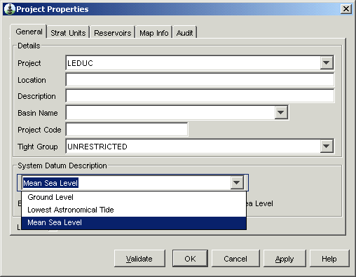
The System Datums defines the absolute zero height or depth for the project and is the depth from which all wellbore depths are measured. This datum does not change over time nor with the change in operations.
The System Datum is defined in the Project Properties > General Tab.
Mean Sea Level (MSL) is the default System Datum. This datum is commonly used, but in specific areas other system datums are commonly used. For example, in parts of Western Europe Normaal Amsterdams Peil (NAP) is used.
When Mean Sea Level is selected as the System Datum the Elevation field is greyed out, as it is the default System Datum, absolute zero.
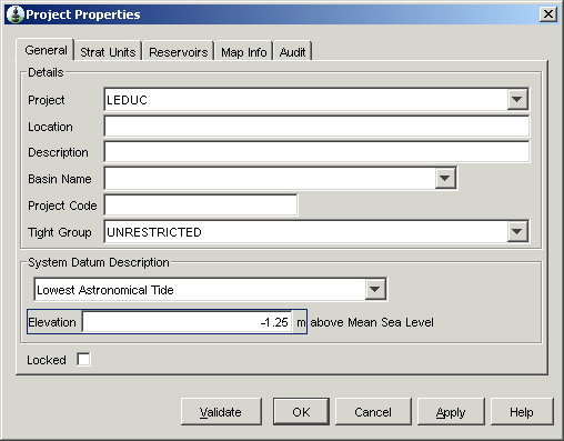
The Elevation field is used to define the depth of the System Datum above or below Mean Sea Level. Elevations above MSL are entered as a positive number and elevations below MSL are entered as a negative number.
For example,
if Lowest Astronomical Tide (LAT) is selected the elevation is entered as a negative number (e.g., -1.5 m), since LAT is 1.5 meters below MSL.
if High Astronomical Tide (HAT) is selected the elevation is entered as a positive number (e.g., 2 m), since HAT is 2 meters above MSL.
The Elevation field is also defined in the Project Properties > General tab.
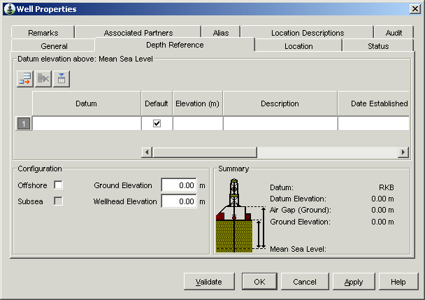
The Reference Datum Levels (RDL) (or Local Datum) is the reference elevation for depths displayed or entered in all EDM™ database applications.
The Reference Datum Levels (RDL) is defined in the Well Properties > Depth Reference Tab.
Reference Datum Level Elevation
The RDL is measured as an elevation above or below the System Datum.
A positive elevation level represents a height above the system datum, a negative elevation level represents a position below the system datum. The Reference Datum Level (as it will be called in Shell) is set in the Well Properties > Depth Reference tab.
The Elevation field is used to define the depth of the RDL above or below System Datum. Elevations above the System Datum are entered as a positive number and elevations below the System Datum are entered as a negative number.
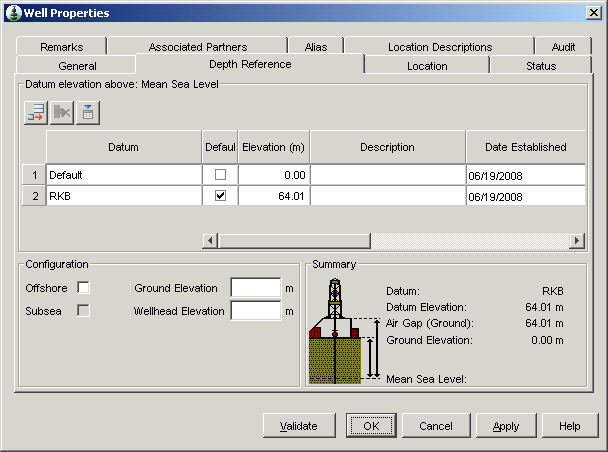
For example, if the System Datum is MSL, then
the elevation of the "Kelly Bushing" RDL, on an offshore Well, is entered as a positive number (e.g., 15m), since the Kelly Bushing is 15m above the Mean Seal Level.
the elevation of the "Mud Line" RDL, on an offshore Well, is entered as a negative number (e.g., 60m), since the Mud Line is 60m below the Mean Seal Level.
Note: The Date Established must be entered for the datum. If it is not a message appears forcing the user to enter a date when a report is being created. This warning appears as a check to confirm the Datum Elevation is correctly set to 0.
The Elevation field is also defined in the Well Properties > Depth Reference Tab.
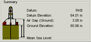
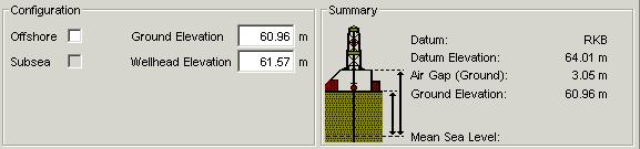
When defining a datum for a Land Well,
the elevation of the ground above the System Datum should be entered in the Ground Elevation field and
the distance from the System Datum to the Wellhead flange should be entered in the Wellhead Elevation field. This value is "measured" and not "calculated", so it will always be a positive number.
See the Land Well Datum Examples topic for examples of Land Well datums.
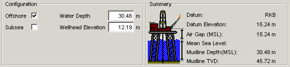
Defining an Offshore Well's Datum
When defining a datum for an Offshore Well,
select the Offshore check box,
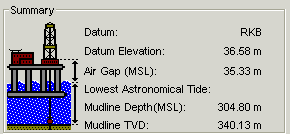
the total depth from the System Datum to the Mudline should entered in the Water Depth field Note: When the System Datum is MSL this would be the water depth. Use caution when entering the Water Depth when the System Datum is not MSL.
the distance from the System Datum to the Wellhead flange should be entered in the Wellhead Elevation field. This value is "measured" and not "calculated", so it will always be a positive number.
See the Offshore Well Datum Examples topic for examples of Offshore Well datums.
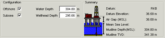
Defining a Subsea Well's Datum
When defining a datum for a Subsea Well,
select the Offshore and Subsea check boxes,
the total depth from the System Datum to the Mudline should entered in the Water Depth field Note: When the System Datum is MSL this would be the water depth. Use caution when entering the Water Depth when the System Datum is not MSL.
the distance from the System Datum to the subsea wellhead flange should be entered in the Wellhead Depth field. This value is used in some calculations when casings are hung from the Wellhead. It is a measured value (not calculated) and is expressed as a positive number. This value is "measured" and not "calculated", so it will always be a positive number.
See the Offshore Well Datum Examples topic for examples of Subsea Well datums.
Air Gap is in some calculations for hydrostatic head. It is calculated as the distance from Ground Level or Mean Sea Level to the Reference Datum Level.
Air Gap is usually a positive number, but in some very specific situations Air Gap can be negative. OpenWells displays a message confirming a negative Air Gap.
Air Gap is calculated as follows:
For offshore Wells: Air Gap = Reference Datum Level Elevation - System Datum Elevation
For land Wells: Air Gap = Reference Datum Level Elevation - Ground Elevation
|
Land Well Air Gap |
Offshore Well Air Gap where System Datum LAT is -1.25m below MSL |
Subsea Well Air Gap where System Datum LAT is -1.25m below MSL |
|
|
|
|
|
|
|
|
Mudline Depth (MSL) only appears for Offshore and Subsea Wells. The Mudline Depth is the depth from the MSL to the mudline and is taken from the Water Depth entered.
Mudline TVD is the mudline depth relative to the System Datum and RDL. This is calculated as follows: Mudline TVD = Water Depth + (Reference Datum Level Elevation + System Datum Elevation)
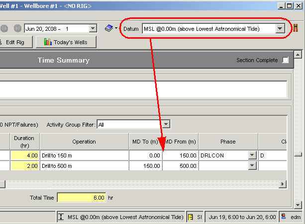
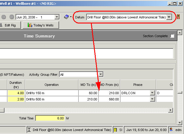
Using Reference Datum Levels in OpenWells
The default Reference Datum Level changes over the life cycle of a Well, with changes in Rigs and viewing data requirements. The Datum Selector in the OpenWells toolbar allows users to change the "viewing" datum on the fly.
**It is important when entering data in reports, such as the Daily Operations, Casing, Cementing, etc. to verify that the data being entered is in correct context to the "viewing" datum. Entering data that is not in context to the current "viewing" datum means the data WILL NOT be correct.
Use caution when switching between EDM applications as the Reference Datum Level may not be the same.
The following two examples show the difference in depths when the "viewing" datum is changed.