Survey Data
Interactive
Well Site > Available
Daily Operations Data
The Survey form is used to record wellbore trajectory
information that assists engineers in determining the position and direction
of the wellbore.
OpenWells® software allows for the recording of surveys
while active work on a Well is ongoing. Surveys entered in OpenWells are
stored in the EDM database as groups of surveys with names, start/end
dates and depths. These surveys are used for Well path calculations that
are displayed on the morning reports generated on the rig.
OpenWells uses the Minimum Curvature method in all survey
calculations. The Minimum Curvature method is based on the wellbore following
an arc on the surface of a sphere between the start and end survey station
vectors. It has a constant radius in 3D space from the center of the sphere.
It is also known as the ’r;Circular Arc’ method.
Survey data is recorded from
the surface and Daily
Operations link.
The Survey form appears allowing
the user to add, review, modify and delete survey data on a daily basis.
For information on how to enter Survey data, see the
Recording Survey Data
topic.
Special Fields and Functions
Show Hide Buttons
The Show
 Hide
Hide
 buttons are used to expand or collapse
a data area. This feature allows users to view the entire details of a
spreadsheet row or just the summary row.
buttons are used to expand or collapse
a data area. This feature allows users to view the entire details of a
spreadsheet row or just the summary row.
For example, in BHA and Work String spreadsheets
these buttons show and hide string components.
In the Costs spreadsheet these buttons show
and hide daily cost details.
In the surveys spreadsheet, these buttons
show and hide survey readings.
Survey Prerequisites
Prior to entering a Survey verify the following
data has been entered:
Default
Reference Datum is selected in the
dialog
Wellhead
Location values are entered in the
dialog
Vertical
Section Angle is entered in the
dialog
Kick
Off MD is entered in the dialog
Plugback
TD is entered in the dialog (optional)
Notes on Surveys in OpenWells:
A survey run
represents the start of the first or a new series of surveys stations
recorded on the wellbore. A new run occurs when there is a change
in the survey tool or method or tie-on.
The Survey Run
spreadsheet displays all survey runs defined for the wellbore on or
before the current report date.
Survey Run information
is shared with the COMPASS™ application using the same EDM database.
Survey Runs created in COMPASS are available in OpenWells. Surveys
locked in COMPASS are also locked in OpenWells.
EDM
Integration Note: All survey stations entered OpenWells are
classified as the "Principle Plan" (ACTUAL). COMPASS™ allows
users to create multiple planned surveys, but only the one classified
as "Principle Plan" (ACTUAL) appear in OpenWells.
Survey's open
in COMPASS are temporarily locked in OpenWells.
Survey Stations
are sorted by the MD field, therefore to insert a survey station add
the row, enter the MD and the spreadsheet automatically inserts the
row by its measured depth.
OpenWells validates
two items in the All Survey Stations spreadsheet:
the depth of
a survey station. A normal, misrun or checkshot survey station cannot
have a measured depth less than the tie-on's measured depth
the time of
the survey cannot fall prior to the tie-on's survey time
Rules that apply
to the survey editor:
the first row,
row 1, is the tie-on point that is defined in Survey Properties and
may not be changed in the Survey Editor
the MD of each
survey station must be greater than the MD of the tie-on point
Inc (Inclination)
must be in the range 0-180 degrees
Azi (Azimuth)
must be in the range 0-360 degrees
Well Azimuth Reference
The Well Azimuth Reference is an OpenWells
Calculated field. This field displays the Well's azimuth reference based
on the Azimuth Reference entered in the Site
Properties dialog (only available
in OpenWells Classic) and the Convergence angle entered in the
dialog. These properties dialogs are only
available in the Classic OpenWells interface for users with permission
to the Site and Well Properties tokens.
Note:
These fields are sometimes defined in
the COMPASS application.
 SAM Indicator
The SAM column displays a red same icon  when another user has the current
survey open. The survey cannot be edited when open by another user.
when another user has the current
survey open. The survey cannot be edited when open by another user.
Survey Run Data
Survey Name
The survey header Name must be unique within
the current Well.
Note:
If a name is not entered in this field
and the user tries to exit the Survey Properties dialog, the following
message appears, "The survey name cannot be empty." The survey
name is also checked against all other survey names used for the Well.
If the name entered is not unique to the Well, the following message appears,
"The survey name already exists within this Well."
Survey Tools
Survey Tools appearing in this picklist are
created in the tab of the Company Properties
dialog. This dialog is only available in the Classic OpenWells interface
for users with permission to the Company Properties tokens.
Integration
Note: The survey tool used here
is very important if OpenWells survey data is shared with COMPASS™, where
it is used to assign a survey tool error model. The specified tool is
used in all anti-collision calculations. Therefore, proper selection and
definition of each tool’s errors and tolerances is critical to proper
compilation of positional uncertainty in COMPASS.
Survey Date Range
The Start and End date fields define a date
range in which the header appears in Daily Operations reports. Survey
headers with a start and end date on or before the current report date
appears in the survey header spreadsheet for that report date.
Tie-on Point area
User
Defined - This option allows the user to enter MD, Inc , Azi,
TVD, N/S and E/W information directly. Use this option when you have
a known Tie-on Point.
From
Wellhead - This option forces the MD to 0, but allows for values
to be entered in the Inc and Azi fields. Use this option when beginning
a new Well the Inc and Azi fields should be zero.
From
Survey - This option displays a list of the previously entered
survey headers in the Survey Name picklist. Once a survey is selected
the tie-on point is entered as the maximum MD entered in the selected
group of surveys.
Note:
Typically there are two situations in
which a survey tie-on would be entered:
Locked
Activate the Locked
check box to lock the survey header at the end of the survey tool run.
This prevents the survey stations from being edited by other users who
do not have the locked data password.
Note:
Surveys locked in OpenWells are also
locked in COMPASS™ and visa versa.
Survey Readings
Editing Rules
The following rules apply to editing in the
Survey spreadsheet:
the first row
is the tie-in point that is defined for the Survey Run and may not
be changed in the spreadsheet
the MD of each
survey station must be greater than the MD of the tie-on point
Inc (Inclination)
must be in the range 0 -180 degrees
Azi (Azimuth)
must be in the range 0 -360 degrees
The depth of
a survey station. A Normal,
Misrun, or Checksum
Station Type cannot have a
measured depth less than the Tie-on's
point measured depth.
The Date/Time
of the survey cannot fall prior to the Tie-on's
points survey Date/Time.
Station Type
The Station Type field is used to communicate
to OpenWells what surveys it should use in calculating the wellpath. Set
all surveys that should be used in calculating the wellpath to NORMAL.
The Station Type picklist contains the following
options:
Tie
On - The first row appearing in the spreadsheet is the Tie-on
Station Type. This row is populated from the Survey Properties dialog's
Tie-on area when the survey header is created. The Station Type picklist
does not list this as an option.
Normal
- This option specifies the survey data as normal and correct and
is used in the survey calculation to complete the wellpath trajectory.
Misrun
- This option specifies bad or suspect survey stations. A row with
Misrun selected is not used in the survey calculations but will be
recorded for later data analysis or survey performance analysis.
Checkshot
- This option specifies a survey that is run a second time to verify
the data. Checkshots can be run at any time and in any depth order,
they do not necessarily follow a depth sequence. A row with Checkshot
selected is not used in the wellpath trajectory calculation but its
location parameters are calculated.
Note: OpenWells software uses the Minimum Curvature
method in all survey calculations.
MD
Enter the MD where the survey occurred. The
current MD (Measured Depth) must be greater than the tie-on MD. The depth
in the first row is defined by the survey header's tie-on point.
Inc
Enter the hole angle from vertical at the
MD where the survey occurred. The inclination must be in the range 0-180
degrees.
Azi
Enter the azimuth at the MD where the survey
occurred. The azimuth must be in the range 0-360 degrees.
TVD
The True Vertical Depth (TVD) is calculated
based on the survey station's measured depth and inclination.
N/S
The Northing (N/S) is calculated based on
the survey station's measured depth, inclination and azimuth.
E/W
The Easting (E/W) is calculated based on
the survey station's measured depth, inclination and azimuth.
Vertical Section Azimuth, DLeg, TFace, Build and
Turn
These fields are calculated based on the
survey station's measured depth, inclination and azimuth.
For more information see Survey
Technical Notes.
Units Picklist 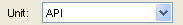
The Unit Management System in the EDM™ database
controls display units in EDT™ applications. Every numerical element in
the EDM database has a storage measure (some known quantity in the physical
world) associated with it such as feet, ft/sec, or °F.
In OpenWells® software, Active Viewing Units
(or Display Units as they are sometimes referred to) are for presentation
purposes only. Display units can changed at any time and do not affect
the quality of the data.
Active Viewing Units for the OpenWells application
are selected from the Unit picklist
located at the top of each page.
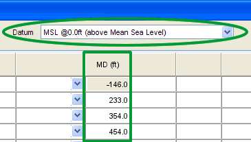
Datum Selector 
The reference point for depths changes over
the life cycle of a Well, with changes in rigs and viewing data requirements.
The Datum Selector, located at the top of
each page, allows users to change displayed the depth reference point
(datum) on the fly.
Changing the depth reference point displays
depths relative to the datum selected. This DOES NOT change the values
in the database itself.
Data MUST be
entered correctly in context to the selected datum reference point.
The following example shows how the viewing
datum affects the data you see.

Print Page 
The Print Page button allows users to print
the current page as it appears in the window.